 The State of Colorado ranks as one of the most strongly mineralized areas in the world. In the United States, Colorado is surpassed only by California in the variety of minerals to be found within its borders. Most minerals in the state do not appear in large concentrations but are widely scattered in small sites throughout the state. Many of those sites are on public lands.
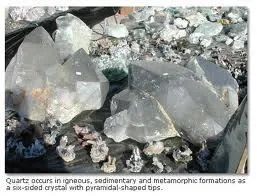
Although Colorado is a leading producer of gold, silver, copper, lead, zinc, uranium, radium, vanadium, and molybdenum, ores are not the only minerals found in the state. At least 30 varieties of gems are found throughout the state of Colorado.
 Semiprecious and precious gems and minerals.
ls are found in a number of locations in the region.
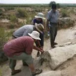
Chaffee County is one of the most productive geological areas in the world. A total of 127 different minerals have been identified in the county. The Columbine Gem and Mineral Society offers outings and excursions to sites around Chaffee County.
Brian Busse out of Salida from American Gemtracker knows the area and organizes outings. Check out his Facebook Page
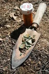
The Rock Doc – In Prospectors Village has a Rock Shop and More. Check out the Rock Shop Facebook Page
The fluorspar mining district at Brown's Canyon was ranked among the top U.S. fluorspar districts during the first half of the 20th century. The 20 mines in the district produced over $5 million in fluorspar. Multicolor fluorspar and small cubes of fluorite can be found in this area as well as some placer gold and copper minerals.
Access: From HWY 285, head east on Chaffee County Roads 194 and 193. Most unmarked roads lead to mines. Road 194 (Hecla Junction Road) passes four old fluorspar mine sites. Minerals include: fluorspar and small specimens of botryoidal fluorite.
Jasper, agate, marble, some geodes, picture sandstone, and rhyolite are found along the old abandoned railroad grade which serves as a summer visitors road over Marshall Pass. Some fossils are found on the western slope.
This region is one of the most interesting mineral areas in North America. It is the third highest gem field in the world and is America’s highest gem field. Rare aquamarine crystals, bright blue beryl, goshenite, phenacite, betrandite, smoky quartz, microcline, topaz, fluorite, and apatite can be found on the talus slopes at around 14,000 feet. The minerals occur in small cavities and pegmatites in granite. But be aware that the weather is always unpredictable. Collecting here is difficult and the collecting season is very short--only about four months--since snow blocks the roads until the end of June. Access along the Mt. Antero Road is slow due to the extremely rough road and many extreme switchbacks. It should be attempted only in a high clearance, 4WD vehicle. Making this trip and climbing to the summit leaves little time for collecting, so start early. Carry emergency supplies and proper clothing. Sudden, dramatic weather changes and thunderstorms are common. Get off the summit in the event of a storm. Collecting on Mt. Antero is for the hardy soul who is in good physical condition.
Sheelite, a very fluorescent tungsten mineral, is found in this “saddle” region situated between the Sangro de Cristo Range on the southeast and the Sawatch Range on the west and northwest. Use a portable black light at night to search for this mineral.
Named in error for garnet found here, Ruby Mountain has been an active specimen collecting area for over 100 years. It is located near Nathrop, six miles south of Buena Vista, and produces small crystals of spessartite garnet (sometimes called mandarin garnet), yellow topaz, and obsidian in perlite. The Ruby Mountain site includes BLM and private land. Until 1992, the site was an open collecting area when local land owners began charging a small fee to collect here. Since then, there have been reports that the current owner(s) forbids collecting. Thus, rockhounders may want to stay on the public lands of this mountain. If you decide to collect here, the easiest access is from the northeast side; the site containing the most minerals is the west slope.
Two other volcanic hills make up this mountainous site—Dorothy Hill and Sugarloaf Mountain—and they also produce specimens. Smoky quartz and sanadine crystals have been found in pegmatites in these areas.
The three volcanic hills are early Tertiary rhyolite dikes characterized by bases of loose rocks and steep slopes alternating with sharp cliffs dropping into the river. Garnet and topaz specimens can be found by sorting the talus rock at the base of the cliffs. Although the upper portion of Ruby Mountain is rhyolitic, the base is a repository for masses of glassy perlite. The perlite can be broken apart into iridescent botryoidal spheres of black obsidian known as marekanite. These are popular with mineral collectors and are called Apache tears.
Access: From Nathrop Post Office, head north on HWY 285 (1.9 mi). Turn right on Chaffee CO 47, cross the Arkansas River (2.6 mi.). Turn right before farmhouse (on left) and cross Denver and Rio Grande Western RR. Veer east and then south on the main road past Sugarloaf Mountain and dry gullies (5.3 mi.). There is a campground at the north end of Ruby Mountain; branch roads go in various directions. Dorothy Hill lies between the highway and the Arkansas River.
The deposits at the Sedalia Mine were discovered in 1881. Production began in 1884 and by World War I, the mine was the largest copper mine in Colorado. Work in the mine ceased in 1910. Though the Sedalia dumps produced a wide array of minerals, they are particularly known for large almandine garnet crystals weighing up to 15 pounds.
This abandoned copper mine, located 4 miles north of Salida in the Trout Creek Hills is noted for an abundance of large almandite-garnet crystals as well as staurlite, actinolite, asbestos, epidote, corundum, spinel, horneblende, chorite minerals, chrysocolla, malachite, and very rare willemite. This area is private property, the gates are locked, and permission must be secured before collecting.
Access: From Salida go north on Colorado 291 toward HWY 285. Cross the Denver & Rio Grande Western RR. Pass Spiral Drive (Chaffee CO 180) to right. Cross bridge over the Arkansas River. Turn right opposite Chaffee CO 35 and cross railroad tracks. Turn immediately right following the road along tracks past two farmhouses. Turn left through gate and close it. Go toward hills and follow along fence. Turn right through the second gate and close it. Park near the mine.
Gold and metal sulfides were discovered in the Mary Murphy Vein in 1870. This initiated a boom that included the Mary Murphy Mine as well as six other mines, two smelters, and one of Colorado's first aerial tramways. Operating continuously until 1926, the Mary Murphy produced over $25 million in gold, silver, lead and zinc. The mine was finally closed in 1952. Minerals to be found in the area around the mines and dumps include: smithsonite and cerrusite, pyrite, chalcopyrite, galena, sphalerite, rhodochrosite, rhodonite, and quartz.
Access: From Nathrop Post Office go south, take Colorado Route 162 west for 16 miles west to St. Elmo. Take Forest Service Road 295 three miles south to mines near the sites of Romley and Pomeroy Gulch.
Numerous highly mineralized formations exist here with abandoned mines every mile or so as you travel over the abandoned narrow gauge railroad bed. Mine dumps produce over 50 varieties of minerals and crystals.
Containing the ghost town of Turret as well as the Calumet Iron Mine, several old gold mines, and numerous pegmatite bodies. Minerals found here include epidote, beryl, muscovite, garnet, jasper, quartz, corundum, feldspar, hematite, actinolite, uralite, biotite, marble, and others. Other mines in the area include the Homestake Mine (albite) and the Independence Mine (molybdenite). The Homestake mine is the site of numerous pegmatite minerals. Feldspar, mica, and quartz are present in the mine dumps and in the area around the mine. The Homestake is also near the massive old quarry, a place where caution is advised if you choose to hike around it. The quarry’s floor is flooded and slippery rocks in wet conditions can be dangerous.
The Calumet Mine ownership has changed hands from time to time and it is necessary to get permission prior to entering the property.
Access: From Salida, take 291 north toward HWY 285. Cross D&RG Western Railroad. Turn right onto Spiral Drive. Cross bridge over Arkansas River. Turn right onto CR 180. Keep left across the railroad at refinery. Continue on Chaffee County 180. Road to right goes up Tenderfoot Hill. Enter San Isabel National Forest through cattle guard. Keep on CR 180 (right road goes 2 miles to Federal granite quarry.) Fork left onto Chaffee County 190. (CR 180 goes to Whitehorn). Junction of Chaffee County 190 to Turret and CO 31 to Calumet Mine. (The Rock Mine is located on the left side of this junction.) At the junction of CR 190 and CO 31, take CO 31 to Calumet Mine. To the Homestake Mine: Continue up 185 another .7 mile where you will see mine dumps directly ahead. 185 Continues around the quarry.
This area is known for fine quartz crystals, limonite cubes, malachite, and galena, all of which can be found on the slopes and in the mine tailings in the area.
This is the location of the famous Devil's Hole Mine. Minerals to be found include rose quartz, muscovite, beryl, garnet and columbite. The quarry is once again active and permission to collect should be obtained from Colorado Quarry.
Jasper and agate float are found in several old pegmatite quarries near Trout Creek Pass. These pegmatites typically have cores of quartz, pink microcline feldspar, and biotite and muscovite mica, with intermediate zones containing quartz, potash feldspar, and albit, as well as niobium and thorium minerals. The south and east slopes of the Trout Creek Pass area are the best places for collecting. Also found in the area are rare earth minerals in the local pegmatites, and fossils in some of the sedimentary beds.
Crystal No. 8 Mine is located on Hwys 24-285 5.9 miles east of the intersection of Hwys 24/285. The mine dump is visible one-quarter mile south of the highway on a low hill across Trout Creek. The Clara May Mine is located one mile east of the Crystal Mine. On Trout Creek Bridge off Hwy 24, follow Forest Service 215 for about one mile. Park in the clearing at the base of the wooded hill and proceed about 250 feet south and up the old mine road. Minerals present include: rose quartz, feldspar, monazite, green fluorite, garnet and muscovite mica.
This mine is located on the south slope of the divide between Brown's Creek and Baldwin Gulch, about 2 miles southwest of Mt. Antero, at an altitude of 12,500 feet. It can be reached from the southeast via a hiking trail up Brown’s Creek from Hwy 285 near Nathrop, or by the jeep road up Baldwin Gulch from Chalk Creek to Mt. Antero. The mine is accessed from the Mt. Antero road at an intersection in the saddle between Mt. Antero and Mt. White. The mine yields specimens of beryl variety aquamarine, biotite, brannerite, fluorite, jarosite, molybdenite, quartz, rutile, and topaz.
Access: From Nathrop Post Office go south to CO162 (follows Chalk Creek west). Take the Baldwin Gulch Road to the summit.
Large commercial deposits of granite, jasper, and crystals are located here. Limonite cubes and fossils can be found near Midway Springs in the vicinity of the quarries.
The largest deposit of travertine in Colorado can be found in Wells Gulch on the borders of Chaffee and Fremont Counties. This stone was used in many important buildings throughout the country including the Dept. of Commerce Building. Also found in the area are jasper, manganese, calcite, rare earth minerals, and Paleozoic fossils. The property is currently privately owned. Blocks as large as 100 tons have been excavated from the site.
From Salida take Hwy 50 east about 6 miles. Turn left on the road to Wellsville. Cross over bridge across the Arkansas River. Cross Denver and Rio Grande Western RR tracks and cattle guard. Take right fork of the road. Go .4 miles and follow road to the west as it goes behind a large mining A frame. Turn hard right and follow the road up the hill. Next road to the right leads to the quarry.
South of the river near Wellsville, this area is a source for many fine dog-toothed calcite crystals in the Pennsylvanian limestone.
This area was the location for many mines that produced malachite, sheelite, and garnet. Check the mine dumps for this material.
Stooping, kneeling, and digging in the Colorado Mountains can leave an avid rockhounder stiff and sore. Not to worry, we have just the “prescription” for these aches and pains, a soak in our natural hot springs. Salida Hot Springs Pool, located along Highway 50, is the largest indoor hot springs pool in the country. This facility is dominated by a large 25 meter, 6 lane pool and a smaller soaking pool. If you are more inclined to soak and relax in a natural hot springs pool, then Mt. Princeton Hot Springs or Cottonwood Hot Springs are ‘just what the doctor ordered.’ Think of it as a “rockaholics intervention!”